( Shhh -- Treeland is Bridgeport’s best kept secret ! )
History
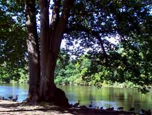
A great friendly neighborhood in northeastern
Bridgeport, Connecticut.
courtesy of Goggle -- click for map link
Click for some great vintage postcards...

An 1874 map ofBridgeport that includes a portion of the Treeland area.

It is difficult to be sure of the orientation and accuracy of the old map vs a satellite map, but it appears a good portion of what we call Treeland (other than Beardsley Park) was land amended from Stratford and Trumbull.
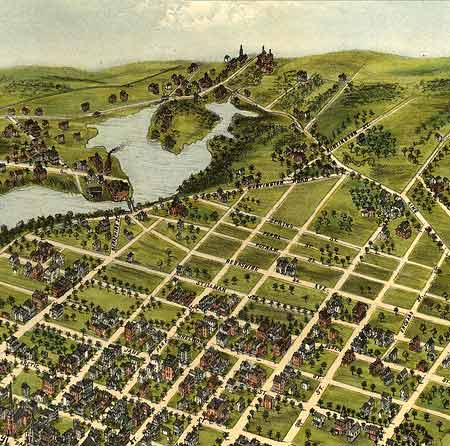
1875 Perspective map of bridgeport (courtesy Uconn Magic Historic maps)
Much of the Beardsley Park area was still in large parcels up through the 1940s. Some of the place names refer to early families in the area.
Beardsley -- you'll note a W. Beardsley on the old map above
Nichols
Noble
Bridgeport, Connecticut was founded in 1836. In 1875, PT Barnum, famous circus owner was elected mayor. He was only in office for a year, but the city is famous for being his "adopted" town. He primarily sparked the steamboat transportation system of the city.
Pequonnock River Mouth Site of Village Bridgeport, situated on a commodious harbor and river estuary, was the site of at least five Native American villages and in 1659 became the site of Connecticut's first Indian reservation. The trading port of Black Rock was settled by the English in 1644, and farming communities at Stratfield and Pembroke by 1660. The city's present territory was then part of the adjoining towns of Fairfield and Stratford.
In 1765, white settlers paid the Pequonnocks to leave, and at the start of the Revolutionary War, some dozen families lived in the town. The townsfolk subsisted by farming, seaborne trading, and whaling and sealing. When Connecticut achieved statehood in 1788, about 100 settlers lived in Bridgeport.
Around 1760, commercial wharves were built on Bridgeport Harbor on the site of the present downtown. Farmers from inland towns brought their farm products to trade for imported goods, and packet boats ran to New York, Boston, and southern ports. One of the earliest merchants was Captain Stephen Burroughs, who was to invent America's decimal monetary system as a replacement for British pounds and shillings.
By the dawn of the new century, the port was thriving, and in 1800 the Borough of Bridgeport was incorporated as the first government of its kind in the state. In 1802 urban expansion caused the removal of the Golden Hill Indians from the last of their downtown reservation lands. Bridgeport became an independent town in 1821 and was soon home to major woolen mill complex and the center for saddle-making on the American continent. The year of its incorporation as a city, 1836, saw the building of one of the country's first railroads north to Albany to intercept trade goods coming east on the Erie Canal.
"The northern portion of current Route 108 was part of the Huntington Turnpike, a toll road built by the Huntington Turnpike Company, which was chartered in May 1828. The Huntington Turnpike went from Bridgeport, through the old town center of Huntington (now known as Shelton), to the west bank of the Housatonic River opposite Derby Landing (the current downtown area of Shelton). The company was dissolved in March 1886. The southern end of the Huntington Turnpike that did not become part of Route 108 is now an unsigned state road (SR) with designations SR 730 (East Main Street to Route 8) in Bridgeport and SR 711 (Route 8 to Route 108) in Trumbull."
from Wikipedia
In 1847 the city became the home of Phineas Taylor (P.T.) Barnum, museum owner, circus founder, and promotional genius. Barnum toured Europe with Bridgeport native "General Tom Thumb" and brought "Swedish Nightingale" Jenny Lind, to see the splendor of his Oriental-styled mansion. He extended his talents to the development of his adopted city. In 1849 Mountain Grove Cemetery was laid out as a monumental sculpture garden based on an English precedent. In 1851 East Bridgeport was developed as a planned residential and manufacturing suburb radiating out from a five-acre central square. Seaside Park, known as the nation's first marine "rural" park, was completed in 1865 by a design team led by Frederick Law Olmsted, one of the men responsible for New York's Central Park.
Industry Shapes Bridgeport's Future
Bridgeport was the home of America's sewing machine industry in the years following the Civil War, and manufacturing continued to be a mainstay of the local economy. The greatest population surge came between 1896 and 1910 when the city swelled from under 50,000 people to more than 100,000. The influx of immigrants seeking factory jobs grew to include some 60 different ethnic groups. Later arrivals included Puerto Ricans, the largest concentration of whom settled on the city's east side.
During the late 1800s, the city was a leader in the production of rifles, corsets, typewriters, organs and pianos, and brass goods. At the beginning of the twentieth century, automobile and submarine manufacture became important. But the most pivotal industry of the city's history—armaments—took off with the commencement of World War I in 1914. Estimates are that during that terrible conflict, Bridgeport made more than two-thirds of the ordinance utilized by both sides in the conflict. The "Russian Rifle" Plant of the Union Metallic Cartridge Company, built to produce 37,500 guns for the troops of Czar Nicholas II, was the largest factory every built in America up to that time.
During the 1920s, the city became a major force in the newly developing aircraft industry. Immigrants who poured into Bridgeport included Igor Sikorsky, who produced flying boats and invented and flew the first helicopter locally. Bridgeporters coped with the Great Depression by electing Socialist Jasper McLevy as mayor during the 1930s, and he retained the office for 24 years. World War II and the ensuring Cold War saw the nation's dependency on the defense industry escalate. During the last two decades of the twentieth century, the city lost many of its one-time industrial giants to out-of-state and foreign competition.
Entering a New Century with New Goals
Today's Bridgeport is a city of diverse ethnic neighborhoods and significant historic architecture. The city has more than 3,000 structures listed on the National Register of Historic Places, more than any other Connecticut municipality. In the late 1990s, the Bridgeport Housing Authority (BHA) implemented several programs to revitalize many of the city's decaying neighborhoods. During the time when the city was a thriving manufacturing center, many housing units were built for its factory workers. The houses, including those in housing developments, began to deteriorate when jobs began disappearing in the 1960s. By 2000, the BHA had redeveloped abandoned housing all over Bridgeport, including a number of single-family homes in three different parts of the city, with federal financial assistance. In 2005, 600 units of downtown housing are in the planning phase and 800 more are being forecast for the future.
In 2003 the city was rocked by the corruption scandal of longtime mayor Joseph P. Ganim who left office at a time of the city's initial stages of resurgence. He was convicted of racketeering, extortion, and bribery and sentenced to imprisonment for nine years. The city rebounded under the guidance of new mayor, John M. Fabrizi, who has worked with city council members to stabilize the fiscal status of the community while aggressively pursuing new economic development highlighted by a mammoth $2 billion in public and private investments.
While Bridgeport has witnessed dramatic population decreases since the 1980s, the numbers are projected to steadily increase from 2005 through 2020 by the Connecticut Office of Policy & Management. And although Connecticut Magazine scored Bridgeport in 2003 as the lowest of 17 major cities within the state in terms of education, crime, and economic condition, the positive growth and active economic planning have infused the community with hopes for prosperous times ahead.
Historical Information: Bridgeport Public Library, Historical Collections, 925 Broad St., Bridgeport, CT 06604; telephone (203)576-7417; fax (203)576-8255