
Medical |
Northrop Genealogy
Homestead
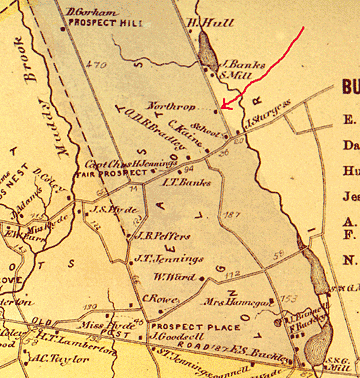
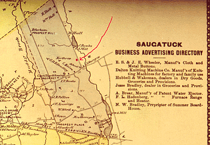
156 Pequot Avenue, Southport, CT
In 1660 in Southport, Sasca Field Road was the name given for Pequot Road of today. The Sasc Field Gate was shown on the map as Horse Tavern Creek which goes under Westway Road of Modern Southport, The King's Highway was, of course also shown in this period and permanent markers now show this route crossing Mill River at a spot just south of Mill Hill Terrace on and intersecting Bronson Road.
In 1673 it was voted by the Town that Mill Hill should remain Common land forever. This was to be a part of the Half Mile of Commons and it was here and on the Mile of Commons that the landowners were to pasture their animals. This Common land was like a big inversted letter "T. The Half Mile of Commons extended from the Saugatuck River on the West to Stratford on the east. The northern limit was Long Lots Road of times past or Hulls Farms Road and Brookside Drive as we know it today. |
In the Eighteenth Century, Mill River village was a small hamlet (still part of Fairfield) of a few houses and a wharf at the mouth of Fairfield's Mill River. By 1831 the village had changed its name to Southport and was a bustling commercial area with warehouses, churches, schools, stores and elegant houses. Southport became a leading coastal port on Long Island Sound, its ships carrying produce and goods back and forth to New York City. A measure of its success is the fact that throughout the 1800s it possessed the only two banks in town. However, competition from steamboats and the railroad took its toll on prosperity. Resourceful shippers teamed with local farmers and businessmen to keep the port going; the Southport onion, a high quality onion was developed and grown on Fairfield's hills and shipped in Southport market boats, keeping the harbor profitable until the end of the century. Today, much of the old village area is part of an historic district, where buildings from three centuries are protected for future generations.
Although few seventeenth-century dwellings remain standing in Fairfield, evidence of the early settlement of the town is visible to this day in the form of the town's road system. Roger Ludlow laid out a grid for his new town; today's Post Road, Old Post Road, Beach Road, and South Benson Road, centered on the Meeting House Green, now the Town Green. On these streets the settlers built their homesteads and the Meeting House, seat of government and place of worship. Around the village was a cluster of common fields where the early settlers raised their crops, grazed livestock and cut timber. Oldfield Road, Benson Road and Unquowa Road were once farm lanes which gave access to these fields. As the town grew and farmsteads were built outside of the village, more highways radiated from the center to provide access: Pequot Road to Greens Farms, Bronson and Mill Plain Roads to Greenfield, Jennings Road to Holland Hill. By the 1670's the settlers began to divide the vacant land in the north of the town between themselves. A series of Long Lots were created, one to a family, running from today's Fairfield Woods Road, Brookside Drive and Hulls Farm Road north to the Danbury bounds. Redding, Weston, and Easton were all once included within the boundaries of Fairfield. Today, if you drive up one of the old "upright highways" - - Sturges Highway, Burr Street, or Morehouse Highway- you are traveling on the access roads to the lands once owned by those families.Fairfield prospered during its first century. Surplus farm products were traded for imported goods. Black Rock Harbor, now part of the City of Bridgeport, became the town's leading port. There, ships were laden with wheat, flax, timber and livestock from the farms and sailed to Boston, New York and harbors as far away as the West Indies. They returned with needed goods such as nails to build their houses, textiles for clothing and furnishings, and molasses to be made into rum. The shipyards and wharves provided employment for many, including slaves. During the colonial period, Fairfield had one of the highest populations of blacks in Connecticut, almost all of whom were enslaved. An idea of how a colonial farming family lived can be gained by a visit to Ogden House, a restored "salt box" farmhouse built circa 1750, at 1520 Bronson Road. The house is operated as a museum by the Fairfield Historical Society.
Revolutionary War
When the Revolutionary War began in the 1770s, Fairfielders were caught in the crisis as much as if not more than the rest of their neighbors in Connecticut. In a predominantly Tory section of the state, the people of Fairfield were early supporters of the cause for Independence. Throughout the war, a constant battle was being fought across Long Island Sound as men from British-controlled Long Island raided the coast in whaleboats and privateers. Gold Selleck Silliman, whose home still stands on Jennings Road, was put in charge of the coastal defenses. In the spring of 1779, he was kidnapped from his home by Tory forces in preparation for a British raid on Fairfield County. His wife watched from their home as, on the morning of July 7, 1779, approximately 2,000 enemy troops landed on Fairfield Beach near Pine Creek Point and proceeded to invade the town. When they left the following evening, the entire town lay in ruins, burned to the ground as punishment for Fairfield's support of the rebel cause. Ten years later, President George Washington noted after traveling through Fairfield, that " the destructive evidences of British cruelty are yet visible both in Norwalk and Fairfield; as there are the chimneys of many burnt houses standing in them yet."
Fairfield recovered slowly from the burning, but soon after the end of the war its houses and public buildings had all been rebuilt. Today's Old Town Hall was erected as the Fairfield County Court House in 1794. A second landmark from this area is the Fairfield Academy, built as a private school in 1804 and operated today as a museum by the Eunice Dennie Burr Chapter of the Daughters of the American Revolution. Also on the Town Green sits the Sun Tavern, rebuilt by its owner, Samuel Penfield, after the burning and now owned by the Town of Fairfield. In the Stratfield section of the town is another landmark of the Federal era, the Stratfield Baptist Church, built in l8l3, the oldest house of worship standing in town.
Greenfield Hill
Greenfield Hill, famous today for its beautiful homes and for the Dogwood Festival held each May, came into its own in the Federal period. In 1783 Timothy Dwight was called to be the pastor of the Greenfield Hill Congregational Church. A man of many talents, Dwight ministered to his flock, wrote poetry, and opened an academy of higher learning for young men and women. He was so successful at this last job that he was asked to become president of Yale College in New Haven. Around the church and green are beautiful examples of homes built by merchants and prosperous farmers during this period. South of the green stands the restored Bronson Windmill, erected in the late nineteenth century to provide water for the Bronson family's estate. The Bronsons are credited with initiating the massive plantings of dogwoods which line the roads of Greenfield Hill.
Southport
In the 1700s, Mill River village was a small hamlet of a few houses and a wharf at the mouth of Fairfield's Mill River. By 1831 the village had changed its name to Southport and was a bustling commercial area with warehouses, churches, schools, stores and elegant houses. Southport became a leading coastal port on Long Island Sound, its ships carrying produce and goods back and forth to New York City. A measure of its success is the fact that throughout the 1800s it possessed the only two banks in town. However, competition from steamboats and the railroad took its toll on prosperity. Resourceful shippers teamed with local farmers and businessmen to keep the port going; the Southport onion, a high quality onion was developed and grown on Fairfield's hills and shipped in Southport market boats, keeping the harbor profitable until the end of the century. Today, much of the old village area is part of an historic district, where buildings from three centuries are protected for future generations.
1800's
The urban development that changed the nature of many of Fairfield's neighbors to the east and west passed the town by in the 1800s. For the most part, Fairfield remained a quiet agricultural town. This unspoiled quality attracted many city dwellers who came to Fairfield starting in the 1840s with the opening of the railroad. They built summer cottages overlooking the Sound and along the main street, now Old Post Road. Many of these elegant dwellings still stand; two of the most spectacular, 'Hearthstone Hall" and "Mailands" are now part of Fairfield University.
World War I and After
World War I brought Fairfield out of its agrarian past by triggering an unprecedented economic boom in Bridgeport, the center of a large munitions industry. The prosperity created a housing shortage in the city, and many of the workers looked to Fairfield to build their homes. The trolley and later the automobile made the countryside accessible to these newly rich members of the middle class, who brought with them new habits, new attitudes, and new modes of dress. The prosperity lasted through the twenties. By the time of the stock market crash in l929, the population had increased to 17,000 from the 6,000 it had been just before the war. Even during the Depression, the town kept growing. The opening of the Connecticut Turnpike in the 1950s brought another onslaught of development to Fairfield'and by the l960s the town's residential, suburban character was firmly established.
ccourtesy 
This page was created in December, 1999.
Information is courtesy of The Fairfield Historical Society, 636 Old Post Road,
Fairfield, Ct 06824
(phone 203-259-1598)


The remainder were placed under the Mohegan, and it is from this group that the two current Pequot tribes have evolved. The Mohegan treated their Pequot so badly that by 1655 the English were forced to remove them. Two reservations were established for the Pequot in 1666 and 1683. By 1762 there were only 140 Pequot, and the decline continued until reaching a low-point of 66 in the 1910 census. At present, the State of Connecticut recognizes two Pequot tribes: Mashantucket and Paucatuck. The 600 Paucatuck (Eastern Pequot) have retained the Lantern Hill Reservation (226 acres) at North Stonington but are not federally recognized. The Mashantucket (Western Pequot) received federal recognition in 1983. Created from lands purchased from the profits of a bingo operation and successful land claim settlement, their Ledyard reservation has expanded to 1,800 acres. Dramatic changes occurred after a gambling casino began to generate enormous profits in 1992, and with 320 members, the Mashantucket have suddenly discovered that they have many "long-lost relatives."
Names
>From the Algonquin word "pekawatawog or pequttoog" meaning "destroyers."
Also called: Pekoath, Pequant, Pequatoo (Dutch), Pequod, Pequin (Sequin), Pyquan,
Sagimo, and Sickenames (Dutch).
Language
Algonquin. Y-dialect, also spoken by the Mohegan, Narragansett, Niantic, and
the Montauk and Shinnecock from the Metoac on the eastern end of Long Island.
Villages
Asupsuck, Aukumbumsk (Awcumbuck), Aushpook, Cosattuck, Cuppunauginnit, Mangunckakuck,
Mashantucket (Maushantuxet), Mystic, Monhunganuck, Nameaug, Natchaug, Noank,
Oneco, Paupattokshick, Pawcatuck (Paucatook, Paweatuck), Pequot (Pequotauk),
Poquonock, Sauquonckackock, Shenecosset, Tatuppequauog, Weinshauks, Wequetequock,
and Wunnashowatookoog.
Allied or Subject Tribes
Eastern and Central Metoac, Manchaug (Nipmuc), Massomuck (Nipmuc), Menunkatuc
(Mattabesic), Monashackotoog (Nipmuc), Pequannock (Mattabesic), Quinebaug (Nipmuc),
Quinnipiac (Mattabesic), Siwanoy (Wappinger), and Western Niantic.
Culture
Highly-organized, aggressive and warlike, the Pequot dominated Connecticut before
1637, a pattern continued later by the closely related Mohegan. As were their
neighbors, the Pequot were an agricultural people who raised corn, beans, squash,
and tobacco. Hunting, with an emphasis on fish and seafood because of their
coastal location, provided the remainder of their diet. Clothing and housing
were also similar - buckskin and semi-permanent villages of medium-sized longhouses
and wigwams. For this reason, it is difficult today to distinguish between the
site of a Pequot village and that of another tribe. The main difference being
that Pequot villages were almost always heavily fortified. The Pequot were not
that much larger than the tribes surrounding them, but they differed from other
Algonquin in their political structure. Highly organized, the strong central
authority exercised by their tribal council and grand sachem gave the Pequot
a considerable military advantage over their neighbors. In this way, the Pequot
were more like the Narragansett of Rhode Island and the Mahican of New York's
Hudson Valley (with whom they are frequently confused).
Obviously a result of constant intertribal warfare over an extended period, the central political power of the Pequot was an exception among the eastern Algonquin tribes who usually lived in peace with each other and therefore had little need of a tribal organization beyond a few villages under a common sachem. Although the exact timing of their migration is unclear, this distinctive characteristic indicates that the Y-dialect tribes (Algonquin (Pequot, Mohegan, Niantic, Narragansett, and the Montauk and Shinnecock of the Metoac) were fairly recent arrivals in southern New England. Most of the older histories written about Native Americans begin with a vague description of where a particular tribe came from before the Europeans "discovered" them, the result of someone asking a question enough until they finally get an answer they wanted. Unfortunately, this has left most people with the impression that tribes never stayed in one place for long, a conclusion which, for obvious reasons, was attractive to Europeans, since it allowed them to ignore native claims to the land.
Actually, migration was not that common until European settlement started displacing the eastern tribes and began a chain reaction of movement to the west. It appears that most of the New England Algonquin occupied their homelands for hundreds, perhaps thousands, of years before the arrival of Europeans in North America. However, the Pequot-Mohegan and the related Y-dialect tribes appear to have been an exception to this general rule. By their own traditions, the Pequot originally came from the upper Hudson Valley where they may well have been a part of the mysterious Adirondack who dominated the individual tribes of the Iroquois before the formation of the Iroquois League. Once they had joined together, the Iroquois were able to defeat the Adirondack whose departure from the New York mountains which bear their name left a large area near Lake Champlain relatively unoccupied. Even though they were physically separated during the historic period, the persistent, mutual animosity which existed between the Pequot and Mohawk after contact seems to confirm this possibility.
History
Situated behind Long Island, the Pequot and their neighbors had little contact
with Europeans before 1600. However, the effects from the European presence
in North American reached them soon afterwards. Warfare precipitated by the
start of the French fur trade in the Canadian Maritimes swept south at the same
time that a sickness left among the Wampanoag and Massachuset by English sailors
on a slave raid depopulated New England spawned three separate epidemics between
1614 and 1617. The Pequot and Narragansett emerged from the chaos as rivals
for the honor of the most powerful tribe in the area. The first meeting of the
Pequot with Europeans occurred in 1614, when the Dutch traders from the Hudson
River Valley began expanding east along the northern shore of Long Island Sound
beyond the Connecticut River. Although the Dutch also visited the Narragansett
villages in Rhode Island, the Pequot's location in eastern Connecticut gave
them an advantage over their rivals. They were not only closer to New Netherlands
(New York), but they controlled the lower Connecticut River, the traditional
native trade route to the beaver areas of the interior.
By 1622 the fur trade on the lower Connecticut River had grown enough that the Dutch established a permanent trading post near Hartford. Their intention was to trade with all of the tribes in the region, but,the Pequot had other ambitions and were determined to dominate the Connecticut trade. They first attacked the Narragansett, not so much to seize a disputed hunting territory in southwest Rhode Island, but to keep these powerful rivals away from the new Dutch post. The next step was for the Pequot to use a combination of intimidation and war to tighten their grip on the region's trade by subjugating the neighboring Nipmuc and Mattabesic. However, some Mattabesic chose to ignore them and tried to trade with the Dutch forcing the Pequot to attack several groups of Mattabesic who had gathered near the Dutch trading post for trade. The resident trader for the Dutch West India Company, Jacob Elekens, had grown annoyed with the Pequot efforts to monopolize the fur trade, and to retaliate, he seized Tatobem, a Pequot sachem, and threatened to kill him unless the Pequot ended their harassment and paid a ransom for his release.
The Pequot brought 140 fathoms of wampum to the post for Tatobem's release, which Elekens accepted, but having expected beaver rather than these strange little shell beads, he killed Tatobem, and all that the Pequot got in exchange for their wampum was his dead body. Understandably outraged, the Pequot attacked and burned the trading post, but fur trade was far too important for the Pequot and Dutch to permit a dead sachem and charred trading post stand in the way of mutual prosperity. The Dutch replaced Elekens with Pieter Barentsen who spoke Algonquin and was trusted by the Pequot, and after a suitable round of apologies and gifts "to cover the dead," trade resumed. Two important changes resulting from this brief confrontation which had lasting impacts. The Dutch never again attempted to prevent the Pequot from dominating the other tribes in area and in effect granted them a monopoly in the Connecticut fur trade. Unchallenged, the Pequot aggressively expanded their control over the Mattabesic tribes along the Connecticut River, either by forcing them to sell their furs to Pequot traders or exacting a heavy tribute for the privilege of trading directly with the Dutch.
The incident had also made the Dutch aware of the value which the natives placed on wampum, and they were quick to realize its potential as a rudimentary currency in the fur trade. Living near the coast, the Pequot did not really have that many beaver in their own homeland, and there was only so much profit to be gained from their role as middlemen in the fur trade. They did, however, have a great deal of wampum, either of their own manufacture or from tribute received from subject tribes. So they were pleased when the Dutch began to accept wampum as payment for goods in lieu of fur. The problem was the Pequot did not have nearly enough wampum to pay for everything they wanted, especially firearms. They solved this by crossing Long Island Sound in their canoes and conquering the Metoac. Since the Metoac were the source of the best wampum in the Northeast, the tribute the Pequot received annually afterwards from the Long Island tribes made them rich and powerful.
Meanwhile, a people which the Pequot would call the "Owanux" had made their first appearance. For the first years after 1620, it appeared the tiny English colony at Plymouth would fail. But somehow, against all odds, it survived, and by 1627 the Dutch had become concerned enough about the possibility of English competition in the fur trade that they sent a representative to Plymouth to negotiate a trade treaty. The resulting document guaranteed the Dutch a monopoly along the entire southern coast of New England including the Connecticut Valley. At most, the Dutch gained only a few years with this maneuver. After the Puritans began arriving in Massachusetts after 1630, Plymouth's agreement with the Dutch was generally ignored. By 1633 Boston traders had reached the Connecticut River and built a trading post at Windsor. A violation of their 1627 agreement, the English post intercepted furs from the interior before they could reach the Dutch downstream. The Dutch responded by purchasing land from the Pequot (actually the Pequot sold land belonging to the Mattabesic) and built a fortified trading post (House of Good Hope).
Native reaction to the English post was mixed. As a rule, the Mattabesic and Nipmuc who were forced to pay tribute welcomed the English seeing, not only an opportunity of better prices for their furs, but a chance to escape the Pequot. This, of course, was not something Sassacus, the Pequot grand sachem, favored. The Pequot were already annoyed by the English manufacture of wampum. The Dutch acceptance of wampum as a currency in their fur trade had not gone unnoticed in the English colonies, and within a few years a cottage industry sprang up in Massachusetts to manufacture wampum. Using steel drills, the English were soon flooding the market which caused a drop in value. Since wampum was the source of their wealth and power, the Pequot did not appreciate this competition. But rather than uniting to destroy the new English trading post on the Connecticut, the Pequot split into pro-Dutch and pro-English factions.
The division had its roots in the personal rivalry between Sassacus and his son-in-law Uncas. Both had been sub-sachems and expected to succeed the grand sachem Wopigwooit when he died in 1631. However, the Pequot council selected Sassacus, and Uncas never accepted this. Their rivalry continued afterwards in bitter council debates over the fur trade. With Sassacus favoring the Dutch, a pro-English faction gathered around Uncas. The arguments grew increasingly heated which made trade along the Connecticut River dangerous for both Dutch and English with the different Pequot factions killing and robbing traders unfortunate enough to cross paths with the wrong group of them. Uncas was eventually forced to leave and form his own village. Other Pequot and Mattabesic soon joined him, and taking their name of Uncas' wolf clan, the Mohegan became a separate tribe hostile to the Pequot. Smallpox hit the Connecticut tribes during the winter of 1633-34. The timing of these events could not have been worse, because in 1634, the Pequot, or rather their western Niantic allies, murdered John Stone, a Boston trader.
In truth, neither "murdered," "Boston," or "trader" does true justice to the memory of this man. Stone was from the West Indies, an occasional trader but full-time pirate, and the Puritans had just banished him from Boston for lewd and immoral conduct. Contemplating his mistreatment by the Puritans, Stone stopped at the mouth of the Connecticut River on the way to Virginia to compensate himself by capturing Western Niantic women and children to sell as slaves in Jamestown. Unfortunately, he got himself killed in the process. Rather than concluding that perhaps Stone was a man who had reaped as he had sown, Boston's Puritan clergy suddenly forgot his many past transgressions and mounted their pulpits to condemn the Pequot as "demons from hell." As tension mounted, Sassacus put aside his personal distaste for the English and dutifully travelled to Massachusetts to keep the peace. The English, however, demanded that he surrender Stone's killers for execution, which Sassacus refused to do. The talks collapsed at this point, Sassacus went home with both sides still angry, and the matter simmered for another year.
In 1635 John Winthrop's Massachusetts Bay Company built Fort Saybrook at the mouth of the Connecticut River. Although isolated in the midst of hostile Pequot and Western Niantic, it effectively blocked Dutch access to the river and forced them to close the House of Good Hope at Hartford. The separation of the Mohegan and smallpox had cost the Pequot almost half of their people, and afterwards they could no longer count on the support of the Dutch. Taking advantage of their weakened condition, the Narragansett struck and reclaimed the lands in southeast Rhode Island they had surrendered in 1622. The following year Thomas Hooker and the first English settlers arrived in Connecticut and settled at Hartford. The Pequot saw themselves being overrun, and while the Mohegan and Mattabesic were welcoming the newcomers, there were numerous confrontations between the English and Pequot which stopped just short of open warfare. For the Pequot, the land being taken was not nearly as important as the loss of their control over subject tribes. After a great deal of harassment, the English in Connecticut learned to hate the Pequot.
The Pequot War (1637) actually began during the summer of 1636 when another Boston trader, John Oldham, was killed as the western Niantic captured his boat near Block Island. Richard Mather, in a sermon delivered in Boston, denounced the Pequot as the "accursed seeds of Canaan," in effect turning the confrontation in Connecticut into a "holy war" of the Puritans against the forces of darkness. With these fiery words urging them to action, Massachusetts, without bothering to consult the colonists in Connecticut, sent a punitive expedition of 90 men under the command of John Endecott (Endicott) to Block Island in August with orders to kill every man and take the women and children prisoners. The English soldiers managed to kill 14 Niantic and an undetermined number of dogs before they escaped into the woods and then burned the village and crops. Endicott then loaded his men back into the boats and sailed over to Fort Saybrook to add some additional soldiers for the second part of his mission - a visit to the Pequot village at the mouth of the Thames river to demand 1,000 fathoms of wampum for the death of Oldham and several Pequot children as hostages.
His arrival at Saybrook was the first indication the Connecticut colonists had of what had happened and since they would bear the brunt of the Pequot and Niantic retaliation, they were very upset. However, the situation was already beyond repair, so they reluctantly provided Endicott with the few men they could spare. Endicott then sailed up the coast to the Pequot village and came ashore to make his demands. The Pequot were just as stunned to learn what had happened as the English had been at Saybrook but managed to stall while everyone escaped into the woods leaving Endicott with an empty village to destroy. Satisfied he had "chastised" enough heathen for one day, Endicott loaded his men into the boats and returned to Boston. The Pequot, however, had recognized some of the Saybrook soldiers, who expecting a siege afterwards, had stolen their corn. Their fears were soon realized. Saybrook was surrounded by Pequot and Niantic warriors who killed anyone trying to leave.
Rather than feeling chastised, the Pequot were furious. During the winter they plotted revenge and sent war belts to the Narragansett and Mohegan asking their help in a war against the English. However, because of their past actions, the Pequot had few friends, and the English found it fairly easy to isolate them. In Rhode Island, Roger Williams used his influence with the Narragansett to convince them not only to refuse the Pequot belt but to ally with the English. Uncas and the Mohegan also declined and chose instead to fight their former tribesmen. Despite this, the Pequot were still formidable and claimed the nominal allegiance of 26 subordinate sachems from other tribes. However, the loyalty of many of their allies was suspect, and when the war began, many of them remained neutral to see "which way the wind blew" before committing themselves.
Early in 1637, Sassacus ordered a series of raids against the Connecticut settlements to retaliate for Endecott's raid of the previous summer. Two hundred warriors attacked Wethersfield on April 12th and killed nine colonists (six men and three women). Other victims were twenty cows and a horse. Taking two teenage girls hostage, the war party loaded their loot into canoes and went home via the Connecticut River. Passing the fort at Saybrook, they taunted the garrison by waving the bloody clothes of their victims. In all, the colonists lost 30 people in these raids, and in May the General Court at Hartford formally declared war. Despite doubts about the loyalty of the Mohegan, a joint expedition of 90 English and 70 Mohegan warriors under Uncas assembled near Hartford to attack the main Pequot fort at Mystic. Commanded by Captain John Mason, an experienced soldier, this tiny army departed on what seemed a suicide mission. Passing down the Connecticut River, it stopped at Fort Saybrook to add a few soldiers and then proceeded up the coast only to discover the Pequot waiting for them at Mystic.
Seeing he was badly outnumbered, Mason prudently decided not to land and continued east to Rhode Island. The Pequot watched his departure and became convinced the English had abandoned the attack and were retreating to Boston. As it turned out, this was a terrible mistake. When Mason reached the Narragansett villages, 200 warriors joined his ranks, and he received their permission to travel overland through Narragansett territory for a surprise attack on Mystic from the rear. With his force now numbering more than 400 men, Mason left the Narragansett villages and moved west across the hills of western Rhode Island. They had barely left before the Narragansett became alarmed by the clumsy manner in which the English soldiers moved through the forest and were certain their entire party would be discovered and ambushed. Only a fiery speech by Uncas challenging their courage kept the Narragansett from leaving the expedition. Despite becoming lost several times, the Mohegan finally located the Pequot fort on May 26th and guided Mason's army to it.
They had not only arrived undiscovered, but the Pequot warriors who normally would have defended Mystic were absent. Lulled into a sense of false security by the sight of the English retreat to the east, the Pequot had formed a war party and gone to raid the settlements near Hartford. Trapping 700 Pequot inside the fort (mostly women, children, and old people), Mason and his men set it afire. Those Pequot not burned to death were killed when they tried to escape. Following Mason's orders, the Narragansett and Mohegan finished any Pequot the English missed but were aghast when the English indiscriminately slaughtered Pequot women and children. Their grim work completed, Mason made a hasty retreat (actually, a headlong rush) to his boats waiting at a rendezvous on the Thames. Sassacus' village was only five miles away, and his warriors were in hot pursuit. During the race for the river, Mason almost stumbled into a returning 300-man war party, but the Pequot were distracted by the smoke from their burning village. The English reached their boats after suffering only two killed and 20 wounded and promptly left. Their native allies were not so fortunate. Abandoned to find their own way home, half of them never made it.
The massacre at Mystic broke the Pequot. Despite the obvious loss of life, the Pequot still had most of their warriors, but the attack demonstrated their fortified villages were vulnerable and deprived the Pequot of the support they needed from their allies. Starving and unable to plant their crops, the Pequot abandoned their villages, separated into small bands, and fled for their lives. As small groups, they were easy prey, and few escaped. After an abortive attempt to find refuge among the Metoac on Long Island, Sassacus in June led 400 of his people west paralleling the coast and its seafood because they were short of food. Slowed by their women and children, the Pequot crossed the Connecticut but killed three Englishmen they encountered near Saybrook. Unfortunate, because it told the English exactly where they were. Hartford declared June 15th as a day of prayer and thanksgiving for the "victory" at Mystic. The English, however, were not satisfied with merely winning the war and had decided to destroy the Pequot.
More than anything else, the English wanted Sassacus. At the end of June, Thomas Staughton landed at Pequot Harbor with 120 men. Finding the Pequot forts abandoned, he started west in pursuit. Mason joined him at Saybrook with 40 men plus Uncas and his Mohegan scouts. With the Mohegan pointing the way, they followed the slow-moving band of Sassacus west. Intent on capturing Sassacus, any Pequot encountered enroute were automatically smashed if they offered the slightest resistance or refused to cooperate - one Pequot sachem near Guilford Harbor was beheaded and his head placed in a tree as a warning (the location is still known as Sachem Head). The English finally caught up with him at Sasqua, a Pequannock (Mattabesic) village near Fairfield, Connecticut. The Pequot retreated to a hidden fort in a nearby a swamp but were surrounded. After negotiations, 200 Pequannock (mostly women and children) were allowed to leave, but the Pequot were well-aware of the fate awaiting them and refused to surrender. During the battle which followed, Sassacus gathered 80 warriors and managed to break free, but 180 Pequot were captured. The others were killed.
Sassacus and his escort fled west to New York. His logical choice for refuge should have been the Mahican (Dutch allies and close relatives), but the Mahican were subject to the Mohawk at the time, so Sassacus was forced to turn to his old enemies for help. The Mohawk, however, had never forgotten who the Pequot were, and they never stood a chance. The Pequot had no sooner reached the Mohawk village, than, without being allowed to speak in council, he and most of his warriors were killed. The few who escaped joined the Mahican at Schaghticoke. The Mohawk cut off Sassacus' head and sent it to Hartford as a gesture of their friendship with the English. Since the General Court in Hartford levied a heavy fine on any tribe providing refuge to the Pequot, there was no place for them to go. The remaining Pequot were hunted down by the English, Mohegan, and Narragansett, and the war ended in a series of small but deadly skirmishes. The remaining Pequot sachems asked for peace and surrendered. With the Pequot defeat, English settlement filled in Connecticut Valley and by 1641 had extended down the coast of western Connecticut as far as Stamford.
Less than half of the 3,000 Pequot alive in 1637 survived the war. Under the peace signed at Hartford in September, 1638, the Pequot were dismembered. The 180 Pequot captured near Fairfield were distributed as slaves: 80 to the Mohegan; 80 to the Narragansett; and 20 to the Eastern Niantic. Of the 80 Pequot which the English captured in other engagements, the 30 warriors were executed, and the women and children were sold as slaves to Bermuda and the West Indies. One Pequot band which surrendered was exiled to Long Island and made subject to the Metoac who by 1653 had become subject to the Narragansett. Other Pequot were distributed as "servants" to New England households where they remained until their deaths. The largest group of Pequot (perhaps as many as 1,000) were placed under the control of Uncas and the Mohegan. The additional manpower provided by the Pequot made the Mohegan the most powerful tribe in southern New England after they defeated the Narragansett in 1644.
Under the Mohegan, the lives of the Pequot were harsh. They were separated into small groups and forbidden to call themselves Pequot. This was bad enough, but the English demand of annual payments of wampum for sparing their lives made the Pequot a burden for the Mohegan who worked them like dogs. By 1655 the Pequot among the Mohegan were treated so badly that the English, who usually overlooked these things, were forced to remove them to separate locations in eastern Connecticut. These eventually became the Mashantucket (Western Pequot) reserve at Ledyard (1666) and the Pawcatuck (Eastern Pequot) reservation at Lantern Hill (1683). Separation from the Mohegan helped, but it did not change the obligation of the Pequot to support the Mohegan in times of war. Pequot warriors joined Mohegan war parties, one of which captured the Narragansett sachem Canonchet during the King Philip's War (1675-76).
Many of the Pequot gradually drifted away from the confines of their small reservations, and their numbers in Connecticut continued to decline until there were only 66 by the time of the 1910 census. Currently, there are almost 1,000 Pequot, but things have changed dramatically for the Mashantucket in recent years. Connecticut sold off 600 acres of their reservation without permission in 1856, and a lawsuit filed in 1976 to recover this land resulted in a $700,000 settlement. Federal recognition was received in 1983, and after a successful bingo operation, an incredibly profitable gambling casino was opened in 1992 which has made the Mashantucket Pequot the wealthiest group of Native Americans in the United States. After a 350 year truce, the Mashantucket may actually have won the Pequot War.
First Nations referred to in this Pequot History:
Iroquois
Mattabesic
Metoac
Mohegan
Narragansett
Niantic
Nipmuc
Wampanoag
courtesy
http://www.dickshovel.com/peq.html
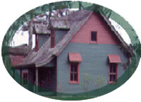
Here is another Northrop brothers project now known as the Victorian cottage on the Fairfield Town hall property
| History of Fairfield - A Summary |
Early Fairfield | Revolutionary War | Greenfield Hill | Southport | 1800s | Mural of the Purchase of Fairfield by Roger Ludlow in 1639
|
This home on Pequot Avenue, Southport, Connecticut is a recently restored example of the Northrop Brothers fine carpentry and building in the Southport-Greeens Farms area.
Image Courtesy of David Parker Associates